Domzira Waterfall Trek
Palghar, Maharashtra
Opens without signal on this phone, with the map file and checklist. Saved for offline →
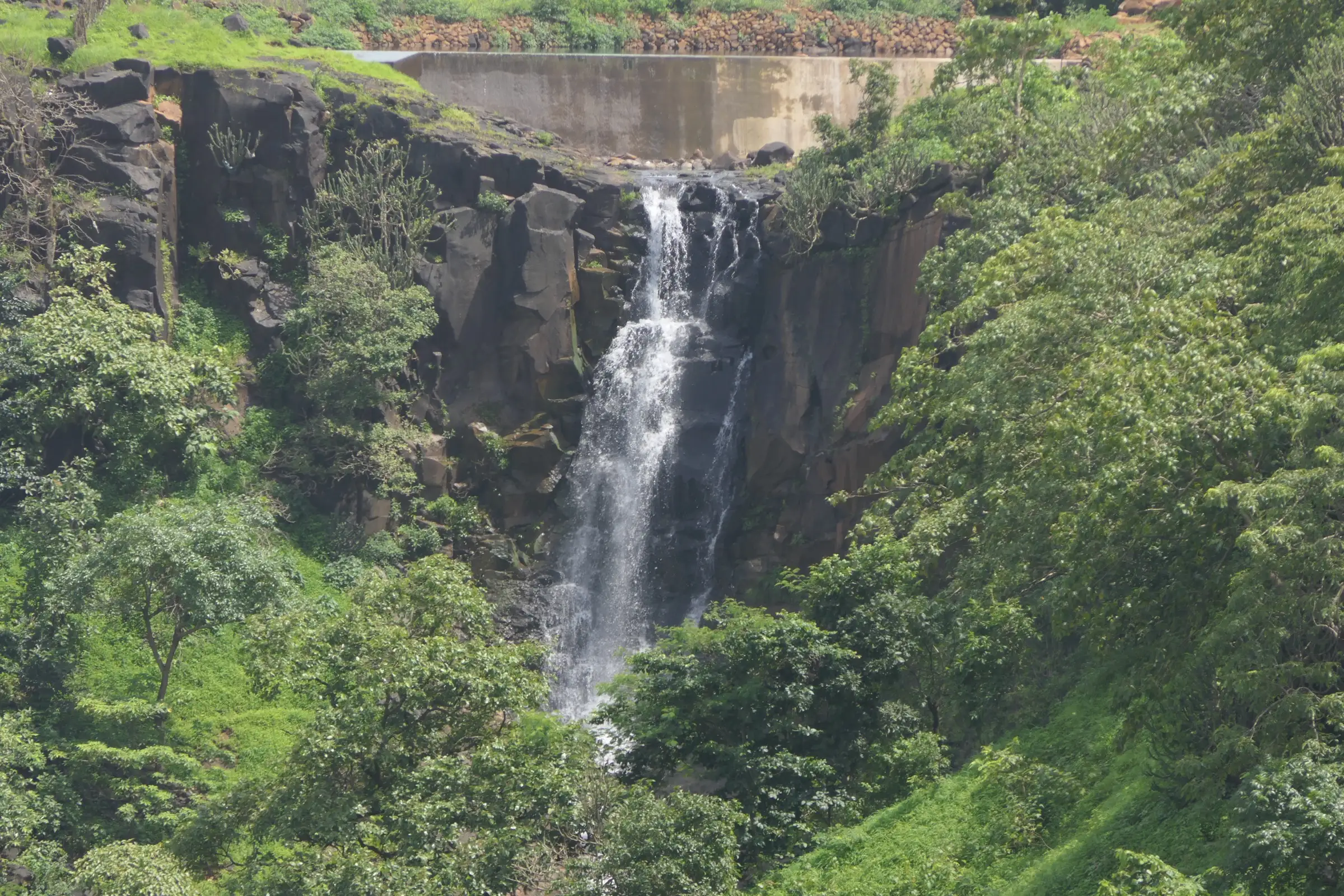
- Max altitude
- 321 m
- Days
- 1 day
- Distance
- 1.8 km
- Difficulty
- Easy
A short walk of about 30 minutes to an hour each way, mostly downhill from the road to a rock-walled pool, with no technical sections. The real hazards are wet rocks, deep water and cliff jumping, not the walk itself.
Photos
On the trail
The route
Day by day
Day 1 · highest point
Road head near Khadkhad Dam → Road head near Khadkhad Dam (via Domzira Waterfall)
321 m → 321 m
Ups and downs
Altitude profile
Where it is
Map
Trailhead and high point only — not a recorded track. Use it with a proper map.
Weather
Next 5 days on the trail
Live forecast for the trailhead and the high point. Mountain weather changes fast — check again on the morning you start.
Trailhead · Road head near Khadkhad Dam, Jawhar
at 321 mLoading forecast…
High point · Domzira Waterfall (approximate; the falls are not mapped)
at 321 mLoading forecast…
Each day: high / low °C · rain mm and chance · snow cm · wind km/h
Weather data: Open-Meteo.comModel forecast, not an official warning. For alerts follow IMD and the local administration.
Plan the trip
How to reach
- Trailhead
- Road head near Khadkhad Dam, Jawhar
- Nearest railway
- Igatpuri (Central Railway, about 60 km) or Palghar (Western Railway, about 70 km from Jawhar)
- Nearest airport
- Mumbai (Chhatrapati Shivaji Maharaj International), about 150 km; Nashik is closer for domestic flights
- By road
- Mumbai (about 130-155 km via the Mumbai-Ahmedabad highway and Manor or Vikramgad to Jawhar; 3.5-5 hours); Pune (about 210 km; 5-6 hours)
- Drive
- About 4.5 h from Mumbai
Plan the trip
Permits and fees
We could not confirm the current permit rules and fees from an official source. Check with the local forest department or tourism office before you go.
Plan the trip
Cost
Self-guided
₹600–1,500
With an operator
₹750–1,499
Per person, ex-Mumbai. Guided prices published by operators: Mischief Treks ₹750 if you reach the base in your own vehicle or ₹1,400 with an AC bus from Mumbai, including breakfast, lunch and local-body charges (batches on hold since April 2025); Treks and Trails India ₹1,299-1,499 Mumbai to Mumbai with breakfast and lunch. Self-guided is an estimate: an MSRTC bus or shared car to Jawhar, a local auto to the road head near Khadkhad Dam, a local guide and a village meal.
Gear
Top picks for this trek
The gear that matters most on this route, chosen from its altitude, season and risks.
 Ad · affiliate link
 Ad · affiliate link
 Ad · affiliate link
 Ad · affiliate link
 Ad · affiliate link
 Ad · affiliate link
- Ad · affiliate link
 Ad · affiliate link
Store buttons open a search on that store, not a product we picked. As an Amazon Associate we earn from qualifying purchases. Photos show the kind of item, not a specific product. Affiliate disclosure
Packing checklist
Matched to this trek: altitude, season, days and the risks on the route.
Packed 0 of 19
Hot days in Mar–May: start at first light and carry extra water and ORS.
Tick each item as it goes in the bag.
Know before you go
Good to know
- Mobile network
- Not confirmed by our sources. Expect weak signal in the valley below the road; make calls from Jawhar.
- Last ATM
- Jawhar town, about 10 km from Khadkhad Dam.
- Nearest hospital
- Jawhar town for first care (Rural Hospital Mokhada is the next option); Nashik or Mumbai for serious cases.
- Water
- Treks and Trails India says there are no restaurants near the trailhead and asks trekkers to carry about 3 litres of water. Do not rely on the canal or pool water.
Highlights
- A hidden cascade between two rock walls, with a large deep pool at the base, in a valley near the Khadkhad Dam canal line
- One of the few Sahyadri falls that runs in summer: Mischief Treks says it flows from March to June, and iVolunteer calls it perennial
- A short jungle walk with birds, butterflies and monkeys, according to Treks and Trails India
- Cliff jumping into the pool is the main draw on organised trips, with life jackets
Risks
- The pool is deep and the site is not guarded. Thrillophilia and Treks and Trails India both warn about deep water; swim or jump only with a life jacket and a trained group leader, and never alone.
- Cliff jumping can cause serious injury. Check the landing depth before every jump and never jump where you cannot see the bottom area clear of rocks.
- Rocks around the falls are slippery and steep, and the trail is wet in the monsoon. Heavy rain can raise the water quickly.
- Overcrowding: Mischief Treks put its Domzira trips on hold from mid-April 2025 because large low-cost groups made the site unsafe. Avoid weekend peaks.
- We found no 2025 or 2026 prohibitory order from the Palghar Collector naming Domzira, but Palghar police have issued monsoon orders for water bodies and waterfalls in past years (for example June-July 2024). Check with Jawhar police or the tehsil office before a monsoon visit.
- The falls are not on Google Maps or OpenStreetMap; go with a local guide from Jawhar.
Know before you go
Questions
Where is Domzira Waterfall?
In Jawhar taluka of Palghar district, Maharashtra, in a valley beside the canal line of Khadkhad Dam, according to Treks and Trails India. The Palghar district website lists 'Domvihira' among Jawhar's tourist places. The exact spot is not on Google Maps, so take a local guide.
How long is the walk to Domzira Waterfall?
Operators disagree. Mischief Treks gives about 900 m and 30 minutes from the trek start point; Treks and Trails India says about 3 km (its itinerary also says around 4 km) and about one hour from the base village. The difference probably depends on where the bus stops.
When is the best time to visit Domzira Waterfall?
Mischief Treks recommends March to June, when the falls still carry water while most other Sahyadri falls are dry. In the monsoon the flow is stronger and the rocks more dangerous.
Can non-swimmers go cliff jumping at Domzira?
Treks and Trails India says non-swimmers can join and that a life jacket is compulsory to enter the water. Thrillophilia warns the pool is very deep in places and unguarded, so go only with an organised group or a local who knows the pool.
How far is Domzira Waterfall from Mumbai?
Jawhar is about 130-155 km from Mumbai, roughly 3.5 to 5 hours by road. Organised groups leave Mumbai late at night or early morning and return the same day.
In an emergency
Save these numbers before you lose signal. Tap to call.
- 112All emergenciesIndia’s single emergency number — works in every state
- 108Ambulance
- 1077District disaster control room
You are in
District: PalgharMaharashtra
- Nearest hospital
- Jawhar town for first care (Rural Hospital Mokhada is the next option); Nashik or Mumbai for serious cases.
- Last ATM
- Jawhar town, about 10 km from Khadkhad Dam.
- Phone network
- Not confirmed by our sources. Expect weak signal in the valley below the road; make calls from Jawhar.
Before you set off
- Tell someone your route and when you will be back.
- Carry a charged phone and a power bank.
- Download an offline map of the route.
- Turn back if the weather turns bad — the mountain will wait.
Questions about Domzira Waterfall
No questions yet. Ask something and trekkers who have done it can answer.
Share your trek photo with #TreksAndTrails
I trekked this
Did Domzira Waterfall look different from this page? Tell us what changed and we will check it.
Where this comes from
Sources
Last reviewed:
- Domzira Waterfall Trek | Cliff Jumping — Treks and Trails India
- Domzira Waterfall Trek for Summer | Mischief Treks | Mumbai — Mischief Treks
- 10 Places to Visit in Jawhar, Tourist Places & Top Attractions — Thrillophilia
- Jawhar, the Land of Waterfalls — iVolunteer (iVol blog)
- SDO Jawhar (tourist places of Jawhar taluka) — Collector Office Palghar (official)
- SRTM 30 m elevation near Khadkhad Dam — OpenTopoData (NASA SRTM 30 m)
Photos: Dinesh Valke from Thane, India, CC BY-SA 2.0; Star Dust H, CC BY-SA 4.0