Patna Waterfall Trek
Pauri Garhwal, Uttarakhand
Opens without signal on this phone, with the map file and checklist. Saved for offline →
- Max altitude
- 520 m
- Days
- 1 day
- Distance
- 3 km
- Difficulty
- Easy
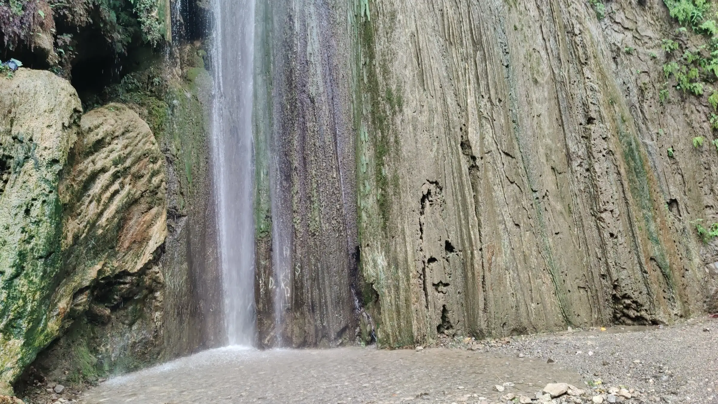
A short walk of about 1.5 km each way on a wide, obvious forest track. It climbs steadily (roughly 140 m from the road to the falls on SRTM elevation data) over dirt, rock and natural stone steps, with shallow stream crossings, but needs no technical skill.
Photos
On the trail
The route
Day by day
Day 1 · highest point
Patna village trek point, Neelkanth Temple Road → Patna village trek point (via Patna Waterfall)
385 m → 520 m → 385 m
Ups and downs
Altitude profile
Where it is
Map
Trailhead and high point only — not a recorded track. Use it with a proper map.
Weather
Next 5 days on the trail
Live forecast for the trailhead and the high point. Mountain weather changes fast — check again on the morning you start.
Trailhead · Patna village trek point, opposite Sidh Bali Temple, Neelkanth Temple Road
at 385 mLoading forecast…
High point · Patna Waterfall
at 520 mLoading forecast…
Each day: high / low °C · rain mm and chance · snow cm · wind km/h
Weather data: Open-Meteo.comModel forecast, not an official warning. For alerts follow IMD and the local administration.
Plan the trip
How to reach
- Trailhead
- Patna village trek point, opposite Sidh Bali Temple, Neelkanth Temple Road (nearest town: Rishikesh)
- Nearest railway
- Yog Nagari Rishikesh, about 10 km; Haridwar Junction, about 25 km, has more trains
- Nearest airport
- Jolly Grant Airport, Dehradun
- By road
- Laxman Jhula, Rishikesh (about 5-6.5 km along Neelkanth Temple Road, past Garud Chatti; taxi, auto, rented scooter or a walk of just over an hour); Haridwar (about 35 km via Rishikesh and Laxman Jhula)
- Drive
- About 6.5 h from Delhi
Plan the trip
Permits and fees
We could not confirm the current permit rules and fees from an official source. Check with the local forest department or tourism office before you go.
Plan the trip
Cost
Self-guided
₹100–700
With an operator
₹3,000–3,700
Per person, ex-Rishikesh (Laxman Jhula). Guided prices seen on 16 Oct 2026: Himalaya Shelter ₹3,500 per person plus 5% GST (pickup at Lakshman Jhula, 4-6 per group); Rishikesh Day Tour's private half-day trip combining Balkumari Temple and Patna Waterfall, sold on Expedia at US$35 (about ₹3,000) per adult with hotel pickup. Self-guided is an estimate: shared auto or taxi share from Laxman Jhula, or a rented scooter (several hundred rupees a day), plus snacks. Three travel guides say there is no entry fee; confirm locally, as the falls lie in the Rajaji forest.
Gear
Top picks for this trek
The gear that matters most on this route, chosen from its altitude, season and risks.
 Ad · affiliate link
 Ad · affiliate link
 Ad · affiliate link
 Ad · affiliate link
 Ad · affiliate link
 Ad · affiliate link
- Ad · affiliate link
 Ad · affiliate link
Store buttons open a search on that store, not a product we picked. As an Amazon Associate we earn from qualifying purchases. Photos show the kind of item, not a specific product. Affiliate disclosure
Packing checklist
Matched to this trek: altitude, season, days and the risks on the route.
Packed 0 of 16
Tick each item as it goes in the bag.
Know before you go
Good to know
- Mobile network
- Not confirmed by our sources. Signal is normally available along Neelkanth Temple Road; expect it to weaken in the forested gully near the falls.
- Last ATM
- Laxman Jhula and Tapovan in Rishikesh; carry cash for roadside stalls.
- Nearest hospital
- Rishikesh (AIIMS Rishikesh and city hospitals), about 10 km away.
- Water
- The stream at the falls only; travel guides say food stalls at the waterfall are few or absent. Carry at least 1 litre per person and treat any stream water.
Highlights
- A tall, fan-shaped limestone waterfall that slides down a moss-streaked cliff into a shallow pool
- A short forest walk through the Rajaji forest that turns off Neelkanth Temple Road a little after Garud Chatti
- Small limestone caves near the falls that visitors explore
- A quieter alternative to Neer Garh and Garud Chatti, especially on weekdays
- An easy half-day outing from Laxman Jhula that families with children can manage
Risks
- Wild elephant country: the falls lie in the Rajaji Tiger Reserve area. In early 2023 an elephant tracker warned visitors about an aggressive male elephant near Garud Chatti and asked them to visit only at midday and leave within 90 minutes. Go in daylight, in a group, and leave if forest staff tell you to.
- One travel writer (2023) saw a 'tourists prohibited' sign at the road and judged it to refer to a side trail to a village; check with forest staff or local stalls before you start.
- Heavy rain can cause flash floods, fast streams and very slippery rocks; in the monsoon the falls spill onto the track and make it muddy. Do not go during heavy rain.
- The falls can dry up to a trickle in summer (April to June) and in winter.
- Wet limestone at the pool is slippery; guides discourage swimming when the flow is strong.
- There are no signs at the trailhead and Google Maps pins have misled visitors; look for the snack stalls opposite Sidh Bali Temple.
Know before you go
Questions
How long is the Patna Waterfall trek?
About 1.5 km each way from Neelkanth Temple Road, so about 3 km return. It takes about 2 hours including time at the waterfall.
Is there an entry fee for Patna Waterfall?
No, according to We Seek Travel and Himalayan Dream Treks, and Chal Banjare's quick facts list it as free (though its FAQ mentions a small maintenance fee). Chal Banjare gives visiting hours of 7 am to 6 pm. Confirm locally, as the falls lie in the Rajaji forest.
How do I reach Patna Waterfall from Rishikesh?
Cross to the Laxman Jhula side and follow Neelkanth Temple Road for about 5-6.5 km, past Garud Chatti. The trail starts beside snack stalls opposite Sidh Bali Temple near Patna village. Take a taxi, auto or rented scooter, or walk for just over an hour.
When is the best time to visit Patna Waterfall?
October to December, just after the monsoon, when the falls still flow well and the trail is drier. In July and August the flow is highest but the trail is slippery and flood-prone, and in summer the falls can dry up.
Can you swim at Patna Waterfall?
There is only a small, shallow pool below the falls where visitors stand under the spray. Guides discourage swimming when the flow is strong because the rocks are slippery.
In an emergency
Save these numbers before you lose signal. Tap to call.
- 112All emergenciesIndia’s single emergency number — works in every state
- 108Ambulance
- 1077District disaster control room
You are in
District: Pauri GarhwalUttarakhand
- Nearest hospital
- Rishikesh (AIIMS Rishikesh and city hospitals), about 10 km away.
- Last ATM
- Laxman Jhula and Tapovan in Rishikesh; carry cash for roadside stalls.
- Phone network
- Not confirmed by our sources. Signal is normally available along Neelkanth Temple Road; expect it to weaken in the forested gully near the falls.
Before you set off
- Tell someone your route and when you will be back.
- Carry a charged phone and a power bank.
- Download an offline map of the route.
- Turn back if the weather turns bad — the mountain will wait.
Questions about Patna Waterfall
No questions yet. Ask something and trekkers who have done it can answer.
Share your trek photo with #TreksAndTrails
I trekked this
Did Patna Waterfall look different from this page? Tell us what changed and we will check it.
Where this comes from
Sources
Last reviewed:
- Patna Waterfall Trek, Rishikesh | Route, Distance & Best Time — Himalaya Shelter
- How to Hike to Patna Waterfall from Rishikesh — We Seek Travel
- Explore best waterfalls in and around Rishikesh — Himalayan Dream Treks
- Patna Waterfall Rishikesh Timings & Trek Entry Fee — Chal Banjare
- Waterfalls in Rishikesh — SOTC
- Rishikesh: Balkumari Temple with Patna Waterfalls Hike — Rishikesh Day Tour (on Expedia)
- Whitewater rafting, waterfalls in Rishikesh — Earth Vagabonds
- SRTM 30 m elevation at the OpenStreetMap 'Patna Waterfalls' node (4700827723) — OpenTopoData (NASA SRTM 30 m)
Photos: Ravi Dwivedi, CC BY-SA 4.0; Thevellichord, CC BY-SA 4.0; Thevellichord, CC BY-SA 4.0