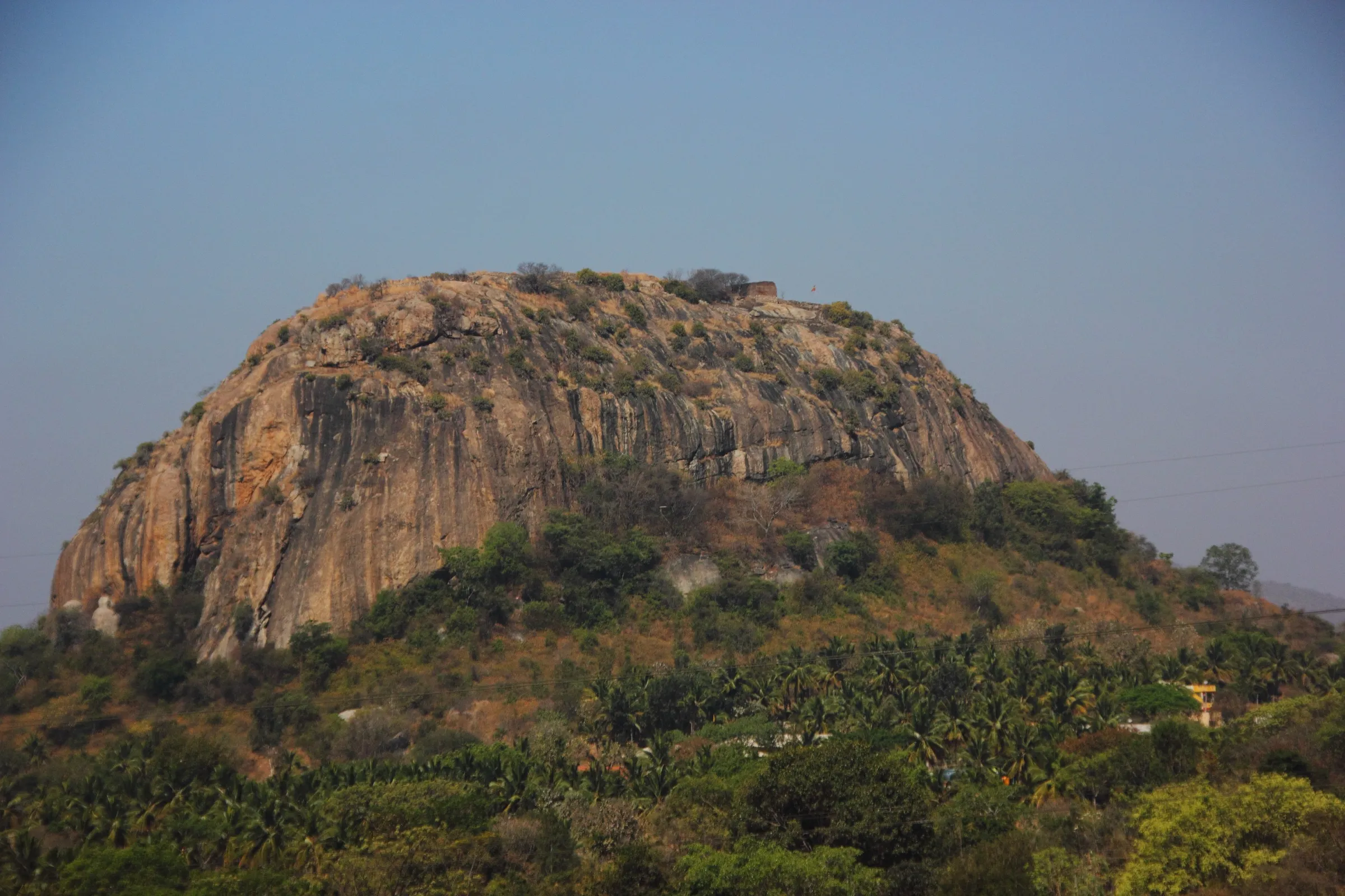
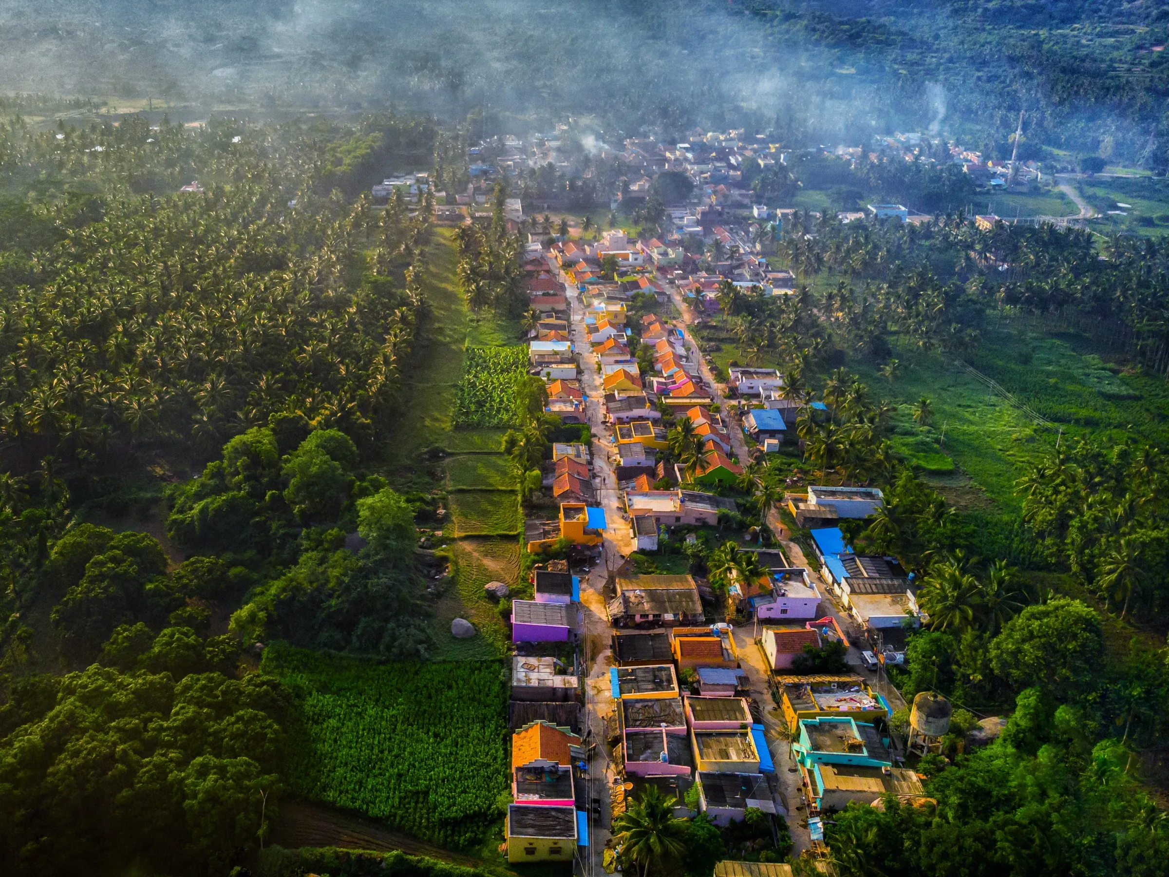
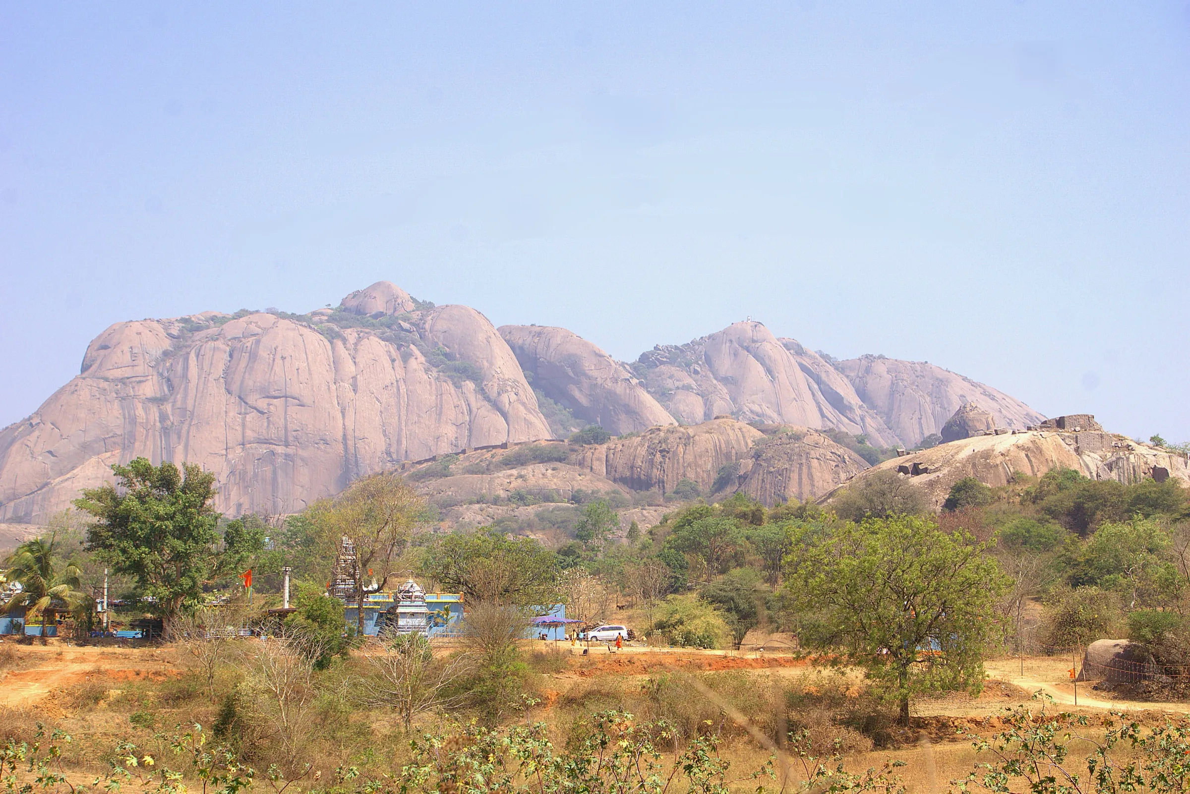
Uttari Betta Trek
Tumakuru, Karnataka
Opens without signal on this phone, with the map file and checklist. Saved for offline →
- Max altitude
- 1,130 m
- Days
- 1 day
- Distance
- 5 km
- Difficulty
- Easy
A short half-day climb of about 5 km return and under 200 m of ascent on village path, rock-cut steps and open granite; operators grade it easy, but the bare rock is slippery when wet and hot in summer.
Photos
On the trail
The route
Day by day
Day 1 · highest point
Hutridurga village → Hutridurga village (via Sankarakumbhi summit)
940 m → 1,130 m → 940 m
Ups and downs
Altitude profile
Where it is
Map
Trailhead and high point only — not a recorded track. Use it with a proper map.
Weather
Next 5 days on the trail
Live forecast for the trailhead and the high point. Mountain weather changes fast — check again on the morning you start.
Trailhead · Hutridurga village, near Kunigal
at 940 mLoading forecast…
High point · Sankarakumbhi summit (Hutridurga Fort Top)
at 1,130 mLoading forecast…
Each day: high / low °C · rain mm and chance · snow cm · wind km/h
Weather data: Open-Meteo.comModel forecast, not an official warning. For alerts follow IMD and the local administration.
Plan the trip
How to reach
- Trailhead
- Hutridurga village, near Kunigal
- Nearest railway
- Kunigal (Bengaluru–Hassan line); Bengaluru for most trains
- Nearest airport
- Kempegowda International Airport, Bengaluru
- By road
- Bengaluru via Magadi and the Kunigal–Magadi road (SH 94), turning off about 7 km before the hill (roughly 55–80 km); Bengaluru via NH 48 to Kunigal / Anchepalya, then about 10 km to the hill
- Drive
- About 2 h from Bengaluru
Plan the trip
Permits and fees
We could not confirm the current permit rules and fees from an official source. Check with the local forest department or tourism office before you go.
Plan the trip
Cost
Self-guided
₹300–1,000
With an operator
₹1,090–1,500
Per person, ex-Bengaluru, day trip. Guided prices published October 2026: Muddie Trails from ₹1,090 (transport, snack pack, trek leader); Treks and Trails India (treksandtrails.org, not affiliated with this site) ₹1,300 with transport, breakfast, packed lunch and forest permission; BMC Adventures ₹1,399 + GST with transport, breakfast and lunch. Self-guided is an estimate: bus or shared car to Kunigal / Hutridurga, food, and any local forest or fort charge (not confirmed).
Gear
Top picks for this trek
The gear that matters most on this route, chosen from its altitude, season and risks.
 Ad · affiliate link
 Ad · affiliate link
 Ad · affiliate link
 Ad · affiliate link
 Ad · affiliate link
 Ad · affiliate link
- Ad · affiliate link
 Ad · affiliate link
Store buttons open a search on that store, not a product we picked. As an Amazon Associate we earn from qualifying purchases. Photos show the kind of item, not a specific product. Affiliate disclosure
Packing checklist
Matched to this trek: altitude, season, days and the risks on the route.
Packed 0 of 17
Tick each item as it goes in the bag.
Know before you go
Good to know
- Mobile network
- Not confirmed by any source; the hill rises from farmland about 15 km from Kunigal, so expect patchy signal on the rock.
- Last ATM
- Kunigal town (about 15 km)
- Nearest hospital
- Kunigal town (about 15 km) for first care; Bengaluru for serious cases
- Water
- No reliable drinking water on the trail; operators ask each trekker to carry 2–3 litres. The rock pools and Dodda Donne, the perennial spring beside the summit temple, are not drinking water. A small shop near the start in the village sells water and tea (reported 2021).
Highlights
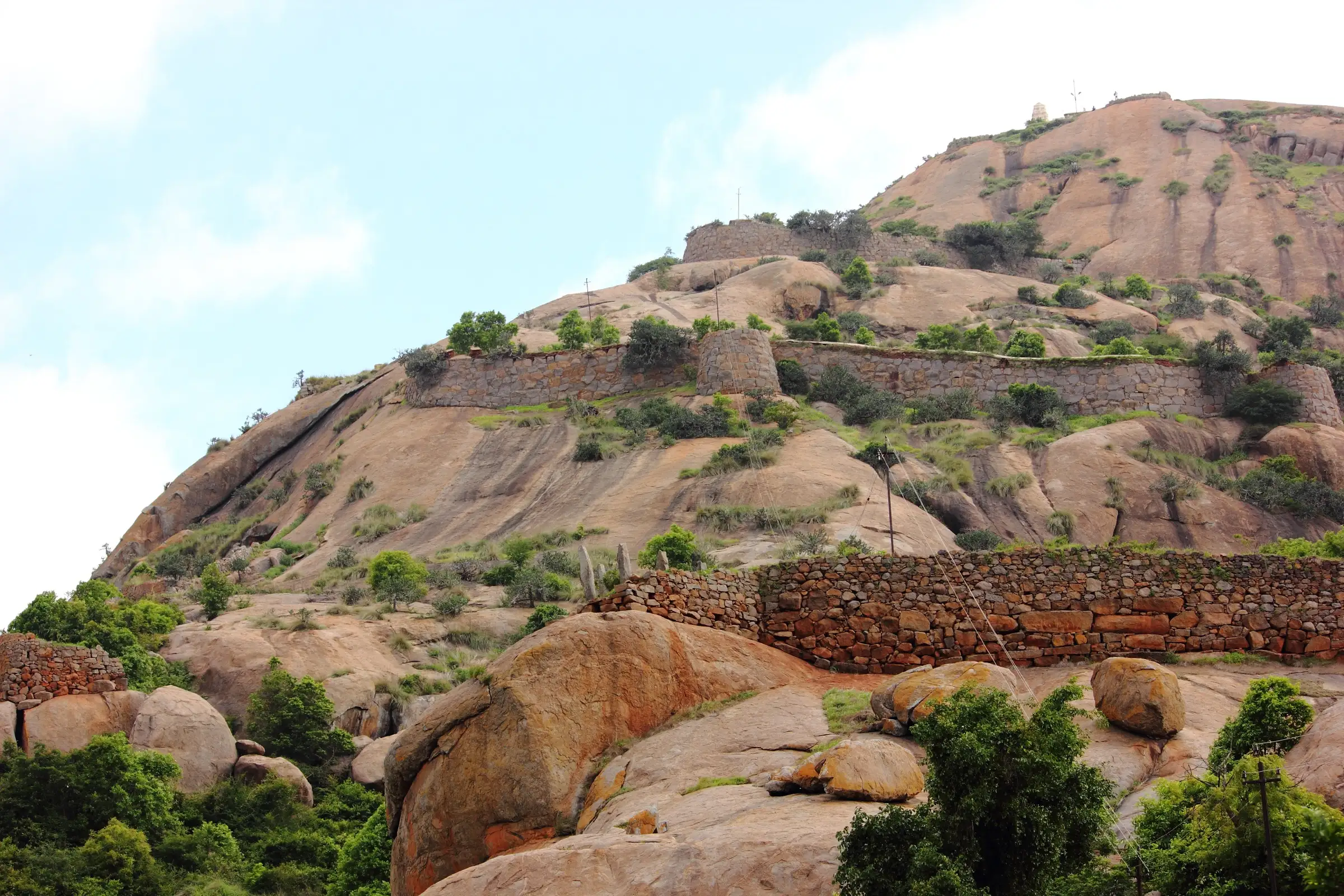
- A climb through the walls of Kempegowda's 16th-century Hutridurga fort, passing a series of old stone gateways
- The Shankareshwara temple of Bhagwan Shiva with a Nandi on the Sankarakumbhi summit, beside the sacred Dodda Donne spring that is said never to dry up, and an Anjaneya temple on the way up
- Rock-cut steps and open granite slabs with wide views of tanks, farmland and neighbouring hills
- One of the Nava Durgas, the nine hill forts around Bengaluru; a popular sunrise trek within about two hours of the city
Risks
- On 11 May 2026 Karnataka's Chief Wildlife Warden suspended trekking paths in areas with leopards, tigers, elephants or bears until each is certified safe. Uttari Betta is not on the Aranya Vihaara booking portal and no order naming it was found; check with the Kunigal forest range office before going.
- Bare granite and rock-cut steps are slippery in the June–September rains.
- Little shade on the rock: March–May is hot, which is why operators switch to pre-dawn sunrise treks then.
- The fort walls and gateways are ruined; the last steep flight of rock steps up to the summit temple is strewn with loose stones, so climb it carefully and keep away from sheer rock edges near the summit.
- Route-finding: direction marks painted on the fort walls are patchy. Keep to the arrow-marked main route; the less-used routes through the fort need a local guide, as people lose the way there.
Know before you go
Questions
How far is Uttari Betta from Bangalore?
The hill (Hutridurga) is in Kunigal taluk, Tumakuru district, about 15 km south-east of Kunigal. Operators quote 55–90 km from Bengaluru depending on the start point; the drive via Magadi Road or NH 48 takes about two hours.
How long and how difficult is the Uttari Betta trek?
Operators and trek reports quote 4–5 km return (one lists up to 7 km) and 2–4 hours of walking, graded easy to easy-moderate. The path climbs through the fort's stone gateways and up rock-cut steps to the summit temple.
What is the best time for Uttari Betta?
October to February is dry and pleasant. June to September is green but the rock is slippery. March to May is hot, so groups start before dawn for the sunrise from the top.
Is there a temple on Uttari Betta?
Yes. The Shankareshwara temple of Bhagwan Shiva, with a Nandi, stands on the Sankarakumbhi summit, and there is an Anjaneya temple midway. The village below has Adinarayana and Veerabhadra temples.
Do I need a permit for Uttari Betta?
One operator says its price includes Forest Department permission, while a 2021 trek report said no permission was needed. We found no official fee or booking rule, and the hill is not on the Aranya Vihaara portal. Self-guided trekkers should check with the Kunigal forest range office.
In an emergency
Save these numbers before you lose signal. Tap to call.
- 112All emergenciesIndia’s single emergency number — works in every state
- 108Ambulance
- 1077District disaster control room
You are in
District: TumakuruKarnataka
- Nearest hospital
- Kunigal town (about 15 km) for first care; Bengaluru for serious cases
- Last ATM
- Kunigal town (about 15 km)
- Phone network
- Not confirmed by any source; the hill rises from farmland about 15 km from Kunigal, so expect patchy signal on the rock.
Before you set off
- Tell someone your route and when you will be back.
- Carry a charged phone and a power bank.
- Download an offline map of the route.
- Turn back if the weather turns bad — the mountain will wait.
Questions about Uttari Betta
No questions yet. Ask something and trekkers who have done it can answer.
Share your trek photo with #TreksAndTrails
I trekked this
Did Uttari Betta look different from this page? Tell us what changed and we will check it.
Where this comes from
Sources
Last reviewed:
- Uttari Betta Trek from Bangalore — Treks and Trails India (treksandtrails.org)
- Day Trek to Uttari Betta — BMC Adventures
- Uttari Betta Trek — Muddie Trails
- Hutridurga — Wikipedia
- Hutridurga Trek - Uttari Betta Trekking — Voyager (imvoyager.com)
- Far from the madding crowd, head to the hills this weekend! — Citizen Matters
- Sunrise Trek to Huthridurga - Uttari Betta — Team G Square
- Karnataka suspends trekking in wildlife areas (Chief Wildlife Warden circular, 11 May 2026) — Green Minute
Photos: Gopakumar V R, CC BY-SA 4.0; Gopakumar V R, CC BY-SA 4.0; Gopakumar V R, CC BY-SA 4.0; Gopakumar V R, CC BY-SA 4.0